
Table of Contents
Oahu’s nature is simply breathtaking – there’s really nothing else like it. The best way to experience it up close? Lace up your hiking shoes and hit the trails. Climb volcanic craters for jaw-dropping panoramic views, or wander through dense, tropical jungle all the way to the sparkling Manoa Falls.
Looking for a serious challenge? The Koko Crater Trail will get your heart pumping with its steep climb – but trust us, the payoff is epic: a full 360° view over Oahu that will make every step worth it. Adventure, sweat, and unforgettable scenery – all in one hike!
- Discover: The perfect reward - relax at a Spa
Get ready for real adventure and unforgettable views! But seriously – don’t hit the trails unprepared. Bring plenty of water – reusable bottles are not only practical, they’re eco-friendly too. Sunscreen and a hat are a must, since many trails offer very little shade. Pro tip: start early, when it’s cooler and the trails are nearly empty.
Our guide shows you the most stunning paths, the best viewpoints, and everything you need for an amazing hiking experience. So lace up your shoes, breathe in that fresh air, and let the adventure begin!
Map of the Best Hikes on Oahu
1 Diamond Head Hike
- Length: 1.6 mi (2.6 km)
- Duration: 1.5–2 hours
- Difficulty: Easy
The Diamond Head Crater Hike is one of the most spectacular hikes on Oahu – a must-do for any Hawaii visitor! This volcanic tuff cone, known to locals as Leʻahi, offers the perfect mix of adventure, history, and breathtaking views.
The crater’s story is just as fascinating: 19th-century British sailors mistook the shiny rocks at the summit for diamonds. No diamonds were found, but the name “Diamond Head” stuck. Today, Leʻahi is part of a state park and a top destination for hikers from around the world.
- Discover: All about the Diamond Head Hike

The hike takes about 1.5 to 2 hours. The trail is partially paved, but don’t underestimate it: there’s very little shade, yet the reward is incredible – 360° panoramic views over Honolulu and the Pacific Ocean! Be sure to bring sunscreen, a hat, and plenty of water. And remember: you’ll need an online reservation to visit, which can be booked up to 14 days in advance.
Diamond Head Crater Hike – See Tours & Prices Below
2 Koko Crater Hike
- Length: 1.6 mi (2.6 km)
- Duration: 1.5–2 hours
- Difficulty: Moderate
The climb up Koko Crater is the ultimate leg workout! You’ll battle your way up 1,048 old railway ties on a steep trail. The hike can be roughly divided into three sections, each one getting progressively tougher.
Our tip: don’t get overconfident – save some energy for the final push. Finding a steady rhythm is tricky because the steps are uneven – sometimes close together, sometimes far apart. Sometimes you’ll need two steps for one tie, other times a big lunge – this hike is no joke!
- Discover: Our complete Koko Crater Guide
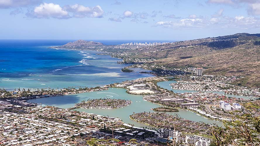
But the little ordeal is worth it, I promise. Because you are 1.207 feet (368 m) above sea level at the top, this view, this panoramic view, is breathtaking! Take your time and enjoy the view over Honolulu, Hanauma Bay, Diamond Head, and much more.
And honestly, enjoy it longer than you usually would. Because you have to go all the way back down, and that is more strenuous for your knees. And honestly, when you reach the bottom, you are exhausted yet flooded with happy hormones – a wonderful experience!
Koko Crater Railway Trail – Compare Guided Hiking Tours
3 Pillbox Hike
- Length: 1.8 mi (2.9 km)
- Duration: 1.5–2 hours
- Difficulty: Moderate
The Kaʻiwa Ridge Trail, better known as the Lanikai Pillbox Hike , is an exciting and sometimes challenging trail with incredible views. There are two starting points: the more popular one is at Kaelepulu Drive, and the other is at Kamahale Street.
Both are well-marked and easy to find, but they start in residential areas with no public parking. Be sure to park responsibly – tickets are actually issued even in the early morning hours. For both starting points, the hike is about 1.8 miles (2.9 km) long with an elevation gain of roughly 623,36ft (190 m). The trails aren’t paved or heavily marked, but the path is clear.

The destination is the old military observation bunkers – now some of the best viewpoints you can imagine. Colorfully painted and covered in graffiti, these decorated concrete platforms are the perfect spot to take in the breathtaking scenery.
Sit back, take a deep breath, and enjoy the view: from Lanikai Beach to Makapu'u Point with its lighthouse, and even the islands of Molokai and Maui, plus so much more. Feel free to explore beyond the main bunker and check out the quieter part of the trail. There you’ll find hidden spots perfect for photos and an amazing perspective of the Koolau Mountain Range.
4 Makapu'u Lighthouse Trail
- Length: 2.5 mi (4 km)
- Duration: 2 hours
- Difficulty: Easy
The Makapu'u Lighthouse Trail is an easy and incredibly rewarding hike with spectacular views of Koko Head, the scenic Makapu'u Beach coastline, and the windswept windward shore.
On clear days, you can even spot the neighboring islands of Moloka'i and Lana'i, which are important bird sanctuaries. And here’s a real highlight: from November to May, humpback whales pass by – so don’t forget your binoculars!
The lighthouse itself has a fascinating story: after a ship ran aground on a reef in 1903, it was built in 1909. According to Hawaiian legend, Makapu'u was home to a goddess with glowing eyes – hence the name Makapu'u Lighthouse. Still in operation today, it features the largest lens of any lighthouse in the United States.
- Discover: Our complete Makapu'u Lighthouse Guide

There’s no shade along the trail up to the viewpoints, so it’s best to start early in the morning or late in the afternoon when it’s cooler. Plan about 2 hours for the round trip, depending on your pace and breaks. The hike is roughly 2.5 miles (4 km) total. This popular trail is open year-round, and leashed dogs are always welcome.
Makapuʻu Lighthouse Trail – Scenic Coastal Walks with Live Pricing
5 Manoa Falls Trail
- Length: 1.7 mi (2.7 km)
- Duration: 1 hour
- Difficulty: Easy
The Manoa Falls Trail lies in the lush Manoa Valley, right in the heart of a tropical rainforest, and is one of Oahu’s most popular hikes. Right from the start, you’ll be amazed by the breathtaking scenery: massive, majestic trees with wide-spreading canopies that form a stunning green roof over the trail. Sound familiar? The trail has been featured in several Hollywood films, including Jurassic Park and Lost.
Thanks to the daily rainfall, the valley has a pleasantly humid climate, and you’ll often catch glimpses of beautiful rainbows. It’s no wonder the Manoa Valley is also nicknamed “Rainbow Valley.”
- Discover: The fantastic Manoa Falls Guide
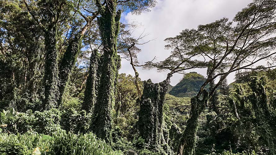
Be careful: the rain often makes the trail muddy, so be sure to wear shoes with good traction. When you reach the bamboo grove, it’s worth taking the detour through it – it’s a bit longer but less muddy, and the atmosphere amid the towering bamboo stalks is incredible. After about 45 minutes of hiking, you’ll reach the final 328 ft (100 m), the steepest part of the trail – but you’ve got this!
At the waterfall, depending on recent rainfall, you’ll either be greeted by a powerful, roaring cascade or a gentle trickle. Even if the 148-foot (45 m) waterfall is flowing lightly, the view and the journey there alone make it an unforgettable experience.
Manoa Falls Trail – Explore the Rainforest & Book Your Adventure
6 Kaʻena Point Trail
- Length: 5 mi or 6.2 mi (8 km or 10 km)
- Duration: 2–3 hours
- Difficulty: Easy
Ka'ena Point Trail is the perfect spot if you want to experience an unforgettable hike with spectacular ocean views. This magical, remote stretch of land is full of breathtaking natural beauty, excellent birdwatching opportunities, and abundant wildlife – a hidden gem that only a few tourists discover.
There are two access points to Kaʻena Point: one in the north and one in the west. The northern entrance, Mokuleia Entrance, takes you along a flat trail through Oahu’s driest region. Along the way, you’ll be treated to stunning views of the mountains, the ocean, and the North Shore.
- Discover: Our complete Kaʻena Point Guide

The western entrance, Waianae Entrance, impresses with its dramatic, mountainous coastline and white sandy beaches. This trail follows the shoreline, offering breathtaking views of steep cliffs and countless small turquoise pools. Both trails ultimately lead to Kaʻena Point – a place where Oahu’s wild beauty truly shines.
7 Kuli'ou'ou Ridge Trail
- Length: 4.7 mi (7.5 km)
- Duration: 3 hours
- Difficulty: Moderate
The Kuliouou Ridge Trail offers a variety of landscapes and stunning panoramic views – one of the most popular trails for catching the sunrise! Plan about 3 hours for the hike, though you can go faster or slower depending on your pace.
The first section takes you through a lush forest with towering trees, before continuing on an unpaved path filled with tree roots – watch your step! Overall, the trail is moderate, with roughly 1,640 feet (500 m) of elevation gain. For most hikers, the stairs are the most challenging part. But the final stretch up to the ridge is well worth it – pause along the way and soak in the view.

At the top, you’re rewarded with a spectacular view! On one side, enjoy a breathtaking panorama from Laie all the way to Makapu'u, while the south side offers amazing views of Diamond Head and Koko Head Crater.
You can return the same way or take a loop via the P’u’ukona viewpoint and the adjacent ridge – known as the Kuliouou Ridge Loop Trail. The loop is roughly the same length but adds about 656 feet (200 m) more elevation.
8 Aiea Loop Trail
- Length: 4.9 mi (8 km)
- Duration: 3 hours
- Difficulty: Easy
A beautiful, easy hike – quiet, relaxing, and off the usual tourist paths. A true hidden gem for anyone who wants to enjoy Oahu’s nature in peace. Plan around 3 hours for the entire route. The trail is open daily from 7:00 AM to 6:45 PM, but we recommend not starting after 4:00 PM.

The loop offers fantastic views throughout – even of the H3 Freeway. If you spot a small side trail, it’s worth exploring, as it usually leads to rewarding viewpoints. After rain, parts of the trail can get quite muddy, making the hike less ideal. The total distance is around 5 miles (8 km), with moderate difficulty, but don’t underestimate it – plan about 2.5 hours to enjoy it at a relaxed pace.
9 Chinamans Hat Hike
- Length: 0.5 mi (0.6 km)
- Duration: 15 Minutes
- Difficulty: Easy
This is a slightly different kind of hike on Oahu – first, you need to reach the small island of Chinaman’s Hat, also known as Mokoli’i. It’s pretty easy to get there by kayak, though you could also swim. By kayak, it takes about 15 to 25 minutes, depending on the current.
Once you land, it’s worth exploring the island a bit before heading up to the summit. The hike is moderately steep, and there are a few spots where you’ll need to do a little climbing – but the supports are clearly visible and helpful. Depending on the weather, the trail can be dusty or muddy, so make sure to wear sturdy, grippy shoes.
- Discover: Hawaiian Phrases

The hike to the top takes 15 minutes if you take it slow. At the top, you will have a fantastic view of the beautiful blue water, the beach, and the Kualoa Regional Park with its mountains. The island got its name because of its shape – it looks like a traditional Chinese hat. Some legends say the hat belonged to a giant that rested under the surface.
Share Now
Jetzt Teilen